Mount Ile Lewotolok Erupts 99 Times in a Single Day
- Editor RM Bambang Murijanto Bagus Kusuma Adji
- 20 Jan 2026
- Voice of Indonesia
RRI.CO.ID, Lembata — Mount Ile Lewotolok, located in Lembata Regency, East Nusa Tenggara (NTT), recorded a staggering 99 eruption events on Monday, January 19, 2026. This surge in volcanic activity has resulted in ashfall affecting 27 villages across the regency.
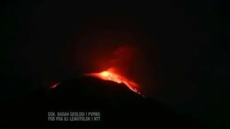
Eruption columns were observed reaching heights of 200 to 500 meters. The plumes varied in color from white and gray to dense black, accompanied by faint rumbling sounds.
"We observed 99 eruptions with heights ranging from 200–500 meters. The smoke transitioned between white, gray, and black, accompanied by weak rumbling," said Stanislaus Ara Kian, an officer at the Ile Lewotolok Volcano Observation Post, on Monday, January 20, 2026.
Stanislaus explained that these eruptions were recorded during a six-hour window between 6 a.m. and 12 a.m. local time. He urged residents and tourists to strictly avoid any activity within a 3-kilometer radius of the crater.
Furthermore, the public has been cautioned regarding the potential for lava avalanches and pyroclastic flows, or hot clouds, in specific sectors of the volcano.
"Residents must remain vigilant against the threat of lava collapses and pyroclastic flows, particularly in the southern, southeastern, western, and northeastern sectors of Ile Lewotolok Volcano," he added.
Andris Koban, Chief Executive of the Lembata Regional Disaster Mitigation Agency (BPBD), confirmed that 27 villages are currently grappling with the effects of the eruption. Beyond the ashfall, lava flows have been spotted moving toward two specific residential areas.
"Lava flows have been monitored descending toward the villages of Jontona and Amakaka," he said.
The BPBD detailed the extensive list of villages impacted by volcanic ashfall, categorizing them by the severity of the exposure. The primary impact zone includes Jontona, Lamaau, Baolaliduli, Aulesa, Lamawolo, Lamatokan, Kalikur WL, Umaleu, Buriwutung, Mampir, and Leuwohung.
In addition to these areas, several other villages are also dealing with significant ash exposure. This secondary group includes Bareng, Kalikur, Normal, Normal 1, Leudanung, Leuwayan, Roma, Hoelea 1, Hoelea 2, Hingalamengi, Meluwitung, Balauring, Wailolong, Lebewala, Wowong, and Nilanapo.
Local administration authorities and relevant agencies continue to monitor the situation closely. Andris urged the community to remain alert and strictly adhere to official safety directives to ensure public safety. (Annaila Azzahra/Bambang MBKA)

